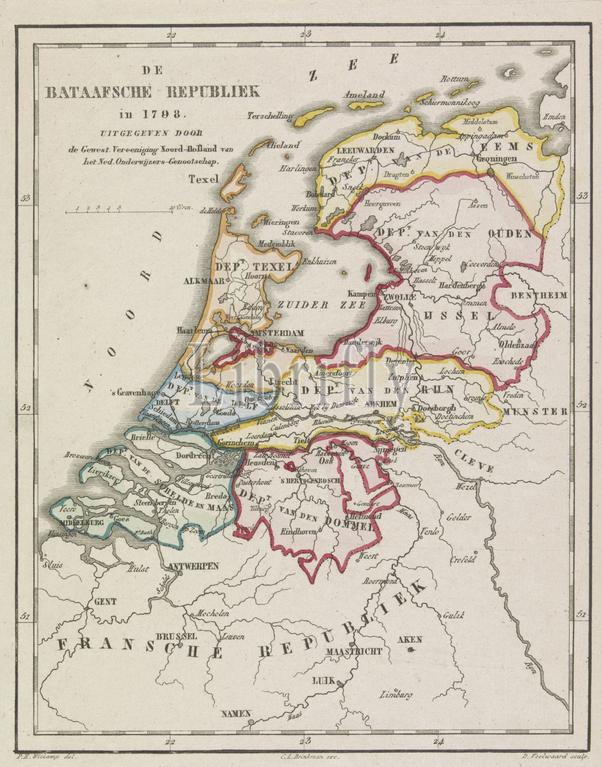
Amsterdam, Brinkman, CL, Witkamp, Pieter Harmen, Netherlands, Veelwaard, Daniël (II), Daniël (I), The Batavian Republic in 1798, Map of the Batavian Republic, 1798, verso - stamped, Map of the Batavian Republic as it was divided into 8 departments in 1798., print, map, prints, Frederik Muller Historieplaten, height 202 mm, width 165 mm, Noord-Nederlands, 1766-08-14 - 1851-02-28, print maker, printmaker, 1850 - 1868, paper, papier, etching, etchings, engraving, engraving (printing process), hand coloring, Nederlands, 1796-12-15 - 1868-11-09, 1816-10-20 - 1892, intermediary draughtsman, after a drawing by, Publication (Event), Publication, Dutch, 1820-09-10 - 1881-09-29, publisher
Keywords:
Amsterdam, Brinkman, Cl, Witkamp, Pieter Harmen, Netherlands, Veelwaard, Daniël, Ii, I, Batavian Republic, 1798, Map, verso - stamped, was divided, 8 departments, print, map, prints, Frederik Muller Historieplaten, height 202 mm, width 165 mm, Noord-Nederlands, 1766-08-14 - 1851-02-28, print maker, printmaker, 1850 - 1868, paper, papier, etching, etchings, engraving, printing process, hand coloring, Nederlands, 1796-12-15 - 1868-11-09, 1816-10-20 - 1892, intermediary draughtsman, drawing, Publication, Event, Dutch, 1820-09-10 - 1881-09-29, publisher
Image ID:
The watermark in the image will not appear on the final download.