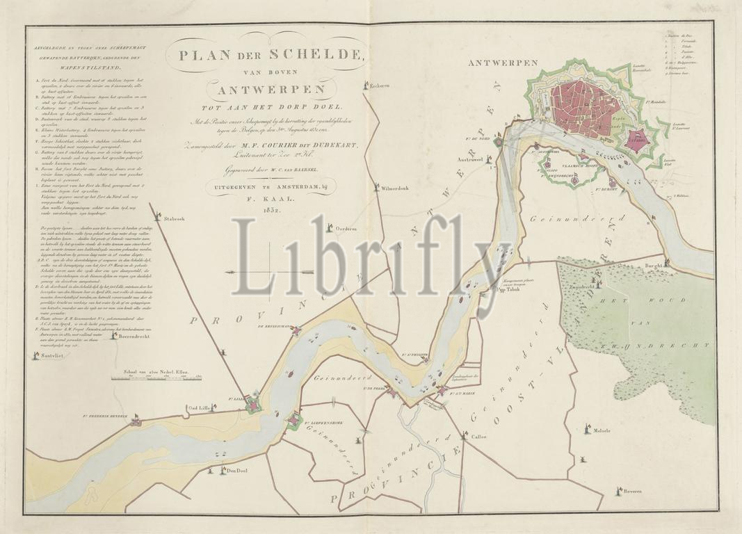
Amsterdam, Kaal, F., Netherlands, Courier dit Dubekart, MF, Baarsel, Willem Cornelis van, Plan of the Scheldt, from above Antwerp to the village of Doel. With the Position of our Shipping Forces at the Resumption of Hostilities against the Belgians, on 3 August 1831, etc., Map of the Scheldt with the Positions of Dutch Warships, 1831, Map of the course of the river Scheldt between Den Doel and the city of Antwerp on 3 August 1831. The positions of the Dutch warships are indicated on the river and numbered 1-40 (key missing). On the left the legend of the Belgian batteries along the river banks AI., print, engraving, engraving (printing process), hand colouring, Frederik Muller Historieplaten, height 483 mm, width 670 mm, 1791 - 1854-04-17, print maker, printmaker, 1832 - 1832, paper, papier, etching, etchings, Dutch, intermediary draughtsman, after a drawing by, Publication (Event), Publication, publisher
Keywords:
Amsterdam, Kaal, F, Netherlands, Courier dit Dubekart, Mf, Baarsel, Willem Cornelis van, Plan, Scheldt, Antwerp, village, Doel, Position, our Shipping Forces, Resumption, Hostilities, Belgians, 3 August 1831, etc, Map, Positions, Dutch Warships, 1831, course, river Scheldt, Den Doel, city, positions, Dutch warships, indicated, river, numbered 1-40, key missing, left, legend, Belgian batteries, river banks AI, print, engraving, printing process, hand colouring, Frederik Muller Historieplaten, height 483 mm, width 670 mm, 1791 - 1854-04-17, print maker, printmaker, 1832 - 1832, paper, papier, etching, etchings, Dutch, intermediary draughtsman, drawing, Publication, Event, publisher
Image ID:
The watermark in the image will not appear on the final download.