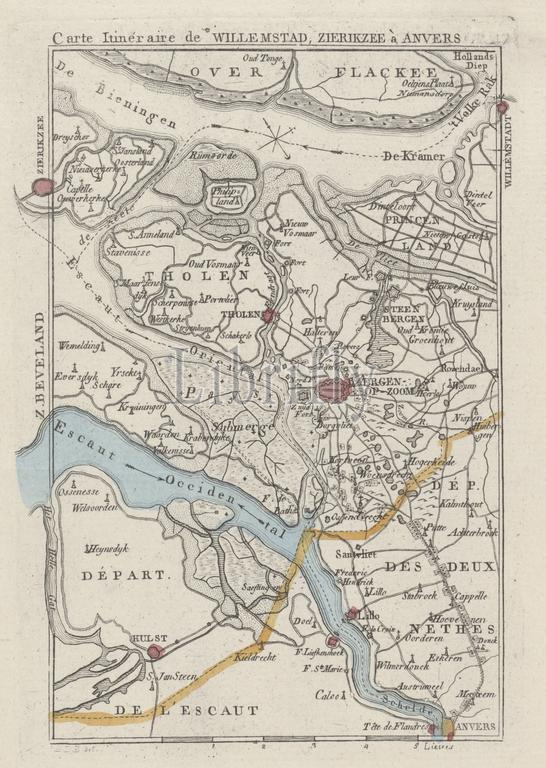
Amsterdam, Maaskamp, Evert, Monogrammist JBDB, Belgium, Carte Itinéraire de Willemstad, Zierikzee à Anvers, Map of the area around Bergen op Zoom, ca. 1830, verso - stamped, ca. 1830. Possibly at the time of the bombardment of Antwerp, October 27, 1830., print, map, prints, Frederik Muller Historieplaten, height 168 mm, width 116 mm, print maker, printmaker, 1830 - 1831, paper, papier, etching, etchings, engraving, engraving (printing process), hand coloring, intermediary draughtsman, after a drawing by, Publication (Event), Publication, Noord-Nederlands, 1769-09-27 - 1834-01-31, publisher
Keywords:
Amsterdam, Maaskamp, Evert, Monogrammist JBDB, Belgium, Carte Itinéraire de Willemstad, Zierikzee à Anvers, Map, area, Bergen op Zoom, ca, 1830, verso - stamped, time, bombardment, Antwerp, October 27, print, map, prints, Frederik Muller Historieplaten, height 168 mm, width 116 mm, print maker, printmaker, 1830 - 1831, paper, papier, etching, etchings, engraving, printing process, hand coloring, intermediary draughtsman, drawing, Publication, Event, Noord-Nederlands, 1769-09-27 - 1834-01-31, publisher
Image ID:
The watermark in the image will not appear on the final download.