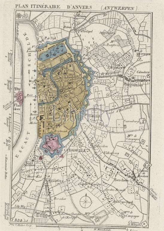
Amsterdam, Maaskamp, Evert, Monogrammist JBDB, Belgium, Maillart, Jeanne, Plan Itinéraire d'Anvers (Antwerp), Map of Antwerp and the Citadel, 1830, verso - stamped, Map of the city of Antwerp with the Citadel, at the time of the bombardment of Antwerp, October 27, 1830. The Dutch warships are indicated on the river, their names are mentioned in the margin on the left. At the bottom the legend 1-32 and two cross-sections of the Citadel., print, engraving, engraving (printing process), hand colouring, Frederik Muller Historieplaten, height 170 mm, width 118 mm, Belgian, 1782, print maker, printmaker, 1830 - 1831, paper, papier, etching, etchings, intermediary draughtsman, after a drawing by, Publication (Event), Publication, Noord-Nederlands, 1769-09-27 - 1834-01-31, publisher
Keywords:
Amsterdam, Maaskamp, Evert, Monogrammist JBDB, Belgium, Maillart, Jeanne, Plan Itinéraire d'Anvers, Antwerp, Map, Citadel, 1830, verso - stamped, city, time, bombardment, October 27, Dutch warships, indicated, river, names, mentioned, margin, left, bottom, legend 1-32, two cross-sections, print, engraving, printing process, hand colouring, Frederik Muller Historieplaten, height 170 mm, width 118 mm, Belgian, 1782, print maker, printmaker, 1830 - 1831, paper, papier, etching, etchings, intermediary draughtsman, drawing, Publication, Event, Noord-Nederlands, 1769-09-27 - 1834-01-31, publisher
Image ID:
The watermark in the image will not appear on the final download.