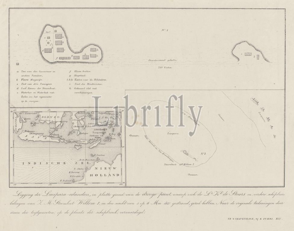
The Hague, Fuhri, Koenraad, Lucipara, Kepulauan, Location of the Lucipara Islands, and map of the dry point on which the Lt. Kl. the Stuers and other castaways of H.M. Steamer Willem I, stranded in the night of 5 to 6 May 1837, have been saved, Map of the Lucipera Islands with the places of residence of the castaways of the steamer Willem I, 1837, verso - stamped, Map of the Lucipera Islands with the places of residence of the castaways of the stranded paddle steamer Willem I, after the ship ran aground in the night of 5 to 6 May 1837. Sheet with three maps: at the top a detailed plan of the island with the location of the various tents, at the bottom left an overview map of the Indian Archipelago, at the bottom right a map of the various islands and the place where the ship ran aground on the coral reef., print, engraving, map, prints, engravings, Frederik Muller Historieplaten, height 256 mm, width 342 mm, print maker, printmaker, 1837 - 1837, paper, lithography (technique), intermediary draughtsman, after a drawing by, Publication (Event), Publication, 1814 - 1858, publisher
Keywords:
Hague, Fuhri, Koenraad, Lucipara, Kepulauan, Location, Lucipara Islands, map, dry point, Lt, Kl, Stuers, castaways, H.M, Steamer Willem I, stranded, night, 5, 6, 1837, saved, Map, Lucipera Islands, places, residence, steamer Willem I, verso - stamped, stranded paddle, steamer, Willem I, ship, ran, aground, Sheet, three maps, top, detailed plan, island, location, various tents, bottom left, overview map, Indian Archipelago, bottom right, various islands, place, coral reef, print, engraving, prints, engravings, Frederik Muller Historieplaten, height 256 mm, width 342 mm, print maker, printmaker, 1837 - 1837, paper, lithography, technique, intermediary draughtsman, drawing, Publication, Event, 1814 - 1858, publisher
Image ID:
The watermark in the image will not appear on the final download.