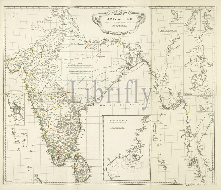
Map of India and the western coastal area of Burma, Siam and Malacca with 8 side cards. Carte de l'Inde: dressage pour la Compagnie des Indes / par le Sr. d'Anville (title on object), Map of India and the western coastal strip of Burma, Siam and Malacca, borders colored, with 8 minor points: surroundings of Goa, mouth of the Ganges, Negrais, the river Aracan, the river Sirian, the Merghi archipelago, Junk Selon area, Ashem area. The unknown area of the Ganges valley has been left blank and there are scales, maps of separate countries or regions, Burma, Thailand, India, Sri Lanka, Bangladesh, Malacca, Ganges., Jean Baptiste Bourguignon d'Anville (mentioned on object), Paris, Nov-1752, paper, engraving, h 886 mm × w 1058 mm
Keywords:
Map, India, western coastal area, Burma, Siam, Malacca, 8 side cards, Carte de l'Inde, dressage pour la Compagnie des Indes, par le Sr, d'Anville, title, object, western coastal strip, borders colored, 8 minor points, surroundings, Goa, mouth, Ganges, Negrais, river Aracan, river Sirian, Merghi archipelago, Junk Selon area, Ashem area, unknown area, Ganges valley, left blank, scales, maps, separate countries, regions, Thailand, Sri Lanka, Bangladesh, Jean Baptiste Bourguignon d'Anville, mentioned, Paris, Nov-1752, paper, engraving
Image ID:
The watermark in the image will not appear on the final download.