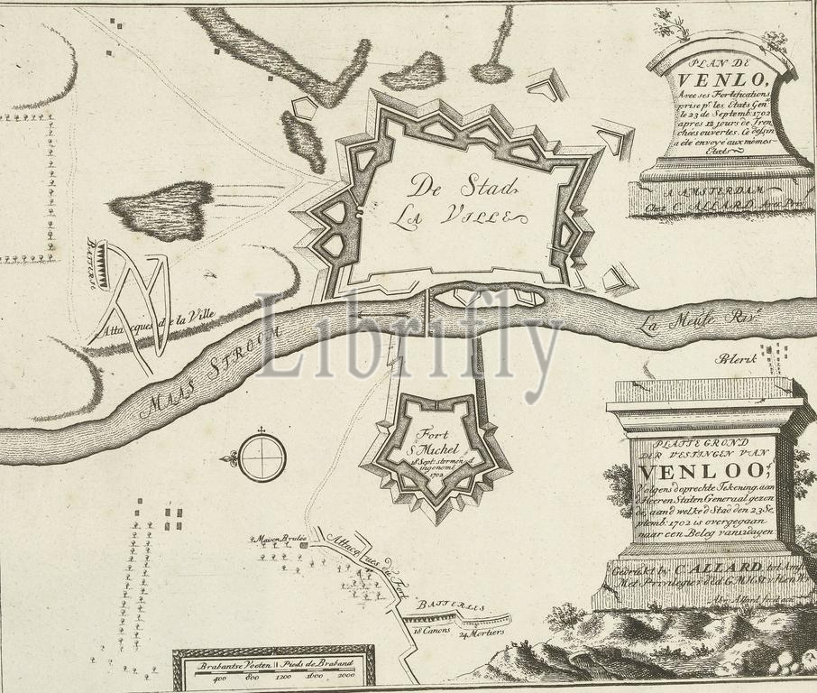
Map of Venlo, ca. 1701-1713, Map of the Fortresses of Venloo, According to the genuine drawing, sent to the Lords of the States General, to whom the city was subjected to a siege of 12 days on September 23, 1702 ( title on object), Les Principales Forteresses & Villes Fortes, d'Espagne, de France, d'Italie, de Savoia, d'Allemagne & des Païs-Bas (...), Accurate Images of the Most Important Strong Cities and Fortresses in Spain, Vrankryk, Italy, Savoyen, Duytsland and the Netherlands (...) (series title on object), Map of the fortifications around and near the city of Venlo. After siege, transferred to the United Netherlands, September 23, 1702. Part of the collected series of 49 plates of renowned strong cities and fortresses in the War of the Spanish Succession, ca. 1701-1713. With the titles in Dutch and French., print, print maker: Abraham Allard, (mentioned on object), after print by: anonymous, publisher: Carel Allard, (mentioned on object), print maker: Amsterdam, after print by: France, publisher: Amsterdam, publisher: Leiden, 1702 - 1714, paper, etching, height, 248 mm × width, 281 mm
Keywords:
Map, Venlo, ca, 1701-1713, Fortresses, Venloo, According, genuine drawing, Lords, States General, whom, city, was, subjected, siege, 12 days, September 23, 1702, title, object, Les Principales Forteresses & Villes Fortes, d'Espagne, de France, d'Italie, de Savoia, d'Allemagne & des Païs-Bas, Accurate Images, Important Strong Cities, Spain, Vrankryk, Italy, Savoyen, Duytsland, Netherlands, series title, fortifications, near, transferred, United Netherlands, Part, collected series, 49 plates, renowned strong cities, fortresses, War, Spanish Succession, titles, Dutch, French, print, print maker, Abraham Allard, mentioned, anonymous, publisher, Carel Allard, Amsterdam, France, Leiden, 1702 - 1714, paper, etching, height, 248 mm × width, 281 mm
Image ID:
The watermark in the image will not appear on the final download.